PLATE TECTONICS
You Might Be a Geologist If …
- Your rock collection occupies more shelf space than your family photos!
Plate tectonics is the theory that makes modern geology work. The basic idea is that the surface of the Earth is made up of several solid plates. They move around slowly floating on a plastic convecting magma. You see, hotter and colder parts of the mantle cause magmas of various compositions and temperatures to circulate, carrying the plates along too! These plates can, at their plate boundaries, get bigger by gaining cooled magma or smaller by losing rock to melting.
This theory helps to explain why there are rock types that indicate desert climates in northern England. Rather than explaining it away by “shifting climatic belts”, it is the land itself that has moved steadily away from the equator over time.
It also explains the shape of the continents; the fact that the coastlines of Africa and South America fit together like a separated picture puzzle. This is obvious looking at any world map. The boundaries of the plates, regardless of type are marked by earthquakes (the black dots) and some by volcanoes.
Figure 1: A map of the plates on the Earth.
Figure 2: Lithosphere structure. Left: oceanic lithosphere. Right: continental lithosphere.
The plates are called the lithosphere (“rock layer”). It averages 100km in thickness. The layer below is the asthenosphere (“weak layer”). It behaves like a thick molten plastic. The lithosphere “slides” over this weak layer.
The lithosphere can be: continental or oceanic. The North American plate has both continental and oceanic lithosphere. The lithosphere cracks like a cookie instead of bending.
Magmas can pick up surrounding cooler rock pieces called xenoliths
A Mid-ocean ridges are where plates get bigger. Here, magma wells up to form ridges which circle the planet. They occur in all of the major oceans.
They are sections of ridge separated by transform faults (Figure 3). The ridge is elevated due to the high heat flow beneath. The heat flow elevates the ridge due to the associated reduction in density. They are typically 2 km higher than the typical ocean depth of 4km.
The earthquakes on a mid-ocean ridge are far from any human life and usually low in magnitude, and therefore not dangerous. They are also shallow and concentrated around the transform faults.
The magma that wells up here is always basic (basaltic) in composition. It forms structures called pillow lavas because the activity is all underwater. (see photo in igneous rocks)
Figure 3: A mid ocean ridge, which is a constructive plate boundary.
B Subduction zones are where plates get smaller. They have major earthquakes and volcanism, especially around the Pacific where they form “The Ring of Fire”. There are three types, as described and shown (Figure 4) below.
The sequence of the figures below is not coincidental. The only lithosphere that can subduct (get drawn down and melted) is oceanic lithosphere, due to its high density compared to continental lithosphere.
- Subduction starts, either ocean-ocean or ocean-continent.
- If subduction started with ocean-ocean, it may progress to ocean-continent if one of the plates has some continental lithosphere in it.
- If both plates have continental lithosphere, continent-continent collision will occur (mountain building). Collisions have no volcanic activity.
|
|
Ocean-ocean collision. Note the trench and volcanic arc. Japan is an example of such an island arc. |
|
|
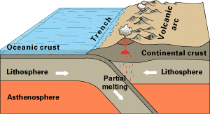
Ocean-continent collision. The trench is still there, but the volcanism occurs on the continental crust. The Andes mountains are an example of this situation. |
|
|
The two plates override each other, thickening the lithosphere and producing mountains. The Himalayas are a good example of this. All mountain chains are formed in this way. Note the lack of volcanoes. |
Figure 4: The three types of destructive margin (subduction zone).
The key features of a subduction zone are a trench and volcanic arc. The volcanoes in destructive plate margins are andesitic (between basaltic and granitic composition, an intermediate magma) in ocean-ocean collisions and
andesitic to granitic (more felsic and therefore lighter) in ocean-continent collisions.
Earthquakes in a destructive margin are much larger and can occur at all depths. They trace the path of the subducting slab as it plunges into the mantle. These earthquakes cause trouble for humans.
C The conservative plate margin is easiest to understand. It is a strike-slip type fault where two adjacent plates move alongside each other, so nothing is gained or lost at this type of margin. The San Andreas fault is the most well known example and is the boundary between the North American plate and the Pacific plate. Located in California, USA, it passes directly through San Francisco. The fault itself is around 30 million years old and has moved a total distance of some 300km in this time (10mm per year).
Conclusion
Plate tectonics is the framework for all modern geology. The theory states that the earth’s surface is made up of several plates that move around, being crushed smaller or made bigger at their margins. The boundaries (margins) have seismic (earthquake) and/or volcanic activity from time to time. These margins can be conservative, constructive or destructive. Constructive margins are the site of mid-ocean ridges, built by rising magmas. Destructive margins form subduction zones where a plate is pushed underneath another.


